Just wanted to check in to give an update as to where I have been and what I have been up to. If you have not figured it out already, I have pretty much given up on the boring daily blog updates, as I am probably at least as sick of writing the same routine stuff, day in and day out, as you were sick of reading it. Not to mention, I need to budget my time more efficiently to maximize my time with family and to get outside as much as possible now that the days are getting longer (would much rather be out living life than writing about it). I’ll continue to post here occasionally if anything particularly interesting comes up, or as time permits.
Everything is going well from a “training” standpoint and I have been getting in a few laps on local peaks each week, along with the usual baby jogger runs and even a few bike rides. I feel like I have built a solid base over the Winter and now within the past few weeks I have been slowly increasing the intensity here and there, which has felt great. Now I just need to be more diligent about maximizing my hard runs and keeping my easy days truly easy.
I confess that I have had a bit of a problem with this in the past, as I am usually trying to fit as much as I can into a short period of time, love to push myself hard, have a tendency to be competitive with others I see doing the same activity, have pent up energy to burn after sitting in an office all day and often times am just overly exuberant about engaging in the activities that I love.
I have also found it especially difficult in the past 19 months (since I became a father of twins) to plan on specific runs with any true reliability. I have always preferred to take each day as it comes and never really thrived on a specific training plan or schedule (I just mentally do better with a less structured approach), but especially since having kids, I never really know if I should hold back today and save it for tomorrow, or give it all I have today, since I don’t know for sure if I will be able to get out for what I want (or need) tomorrow, or the next day, or for several more days. It is always a roll of the dice so to speak.
Recovery is also another challenge. Pre kids, I could simply come home from a long/hard run and focus on eating and resting, but now as soon as I walk in the door, I am full on in high demand dealing with toddlers and catching up on household duties. It is often hours before I can get some food in me and sit down. I could (should) plan better to at least have some sort of recovery drink/food in the car to help ease this issue though.
These are challenges that are typical of being a parent, so I am sure those reading with kids can relate, especially those out there with twins (and I am of course open to any tips/suggestions).
Either way, I am trying my best to make the most of the unpredictability and adapt as necessary. I plan to run the Bolder Boulder for kicks on Monday, May 28th (work is paying for it again, so what the heck) and am also really looking forward to the Mt. Evans Ascent on June 16th and then my goal race of the year, the Pikes Peak Marathon on August 19th.
"Your biggest challenge isn't someone else. Its the ache in your lungs and the burning in your legs, and the voice inside you that yells 'CAN'T', but you don't listen. You just push harder. And then you hear the voice whisper, 'can'. And you discover that the person you thought you were is no match for the one you really are." ~unknown~
Sierra

Sierra
Tuesday, April 24, 2012
Sunday, April 8, 2012
Saturday, 04/07/12 Democrat, Cameron, Lincoln, Bross (Decalibron)
From Kite Lake
7 miles/3,504 vert./3:21
Start: 8:34am
Democrat: 9:33 (then a 10 minute break)
Cameron: 10:28
Lincoln: 10:39 (then another 10 or so minute stop)
Bross: 11:18
Finish: 11:55am
Homie, Sierra and I got out for a long overdue outing on the "Decalibron" Saturday. We were able to drive all the way to Kite Lake (unusual for early April), as there is very little snow and it had been plowed because of an incident a few weeks ago.
Took it pretty easy for the most part, just casually hiking and chatting most of the time. There was very little snow on the route, but Microspikes were quite helpful at times, primarily on the upper section of Democrat, but otherwise were just a luxury (many on/offs).
The day was very clear, but it was very cold and windy most of the time, which had us bundled up pretty good under winter hats, balaclavas, softshells, hardshells and I was even happy to have my warmest Winter mitts. Homie and I were not digging the wind/cold so much, but Sierra was really loving it and was totally in her element. It was great to get to the higher elevations, as it has been over 3 months. Even though our pace was pretty relaxed for the most part, I felt surprisingly good at 14,000 feet and hope to start getting up there a bit more regularly.
A few pics:
Sierra on Democrat and very happy to be back at 14,000+ feet
Quandary, North Star, Lincoln, Cameron
Sierra on Lincoln
Back at Cameron from Lincoln
Bross is next and last
You know it has to be cold when you see Homie bundled up like this.
My best mountain pal
Shedding layers near the end.
Wednesday, April 4, 2012
4x4 Nuttiness
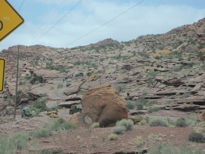
Here are a few videos and some pictures of the 4x4 craziness we witnessed:
It took a while for this guy to give up on the hardest line and pick something a bit easier and we were certain he was going to flip over. The sound of the tires squealing on the slickrock sounded like a barking sea lion (which I mentioned to them and they got a big kick out of it, as if it had never crossed their mind in all their years of doing this)
This crawler was the most insane. Adjustable shocks, steerable rear wheels, etc.... built from the ground up specifically for this. He tried and tried to get up one particular wall, then tried an overhanging pour off that was higher and even more improbable. The highlight was when he went vertical and the cooler full of beer fell off and exploded on the ground (none of which was damaged much to their delight). Made for some great laughs.
Here is a short clip I got while finishing up the Moab Rim hike/run. In several spots, a tip over would deposit you on the Kane Creek Road ~100 or more feet below.
A few pictures of 4x4 related action over the weekend.
Reminds me of the Stompers I had as a kid
This is wicked steep, had to walk far left
Looking back up. The group of jeepers thought we were nuts being out there walking. We thought they were nuts for driving this stuff.
Just in case you need some winch assistance
Dirtbiking would be the way to go (though it still looked very difficult)
A surprising amount of Jeeps had kids in them, some quite young and not looking like they were having a particularly good time. One 11 or 12 year old was even driving.
Hmmm... Let's see if we can make it over this!
Oops. HURRY, SAVE THE BEER!!!!
Allison wishing she had a 4x4 of her own
Allison in the picture for scale. This is just a typical obstacle.
Straight up
Cresting, but does not look as extreme as it really is.
Through the potholes
Great ramp action
Wednesday, 04/04/12 S. Boulder/Bear Peak
From S. Mesa TH
7.48 miles/3,183 vert./2:19:16/avg. HR 135 Garmin Data
Easy hike/jog with Sierra this morning (about 75% was hiking). Towhee was aweful mud, the type that clumps up in several lb chunks on the bottom of your feet and causes complete loss of traction. Shadow was increasingly snowy, not too slick on the up, but I was the first one through today and as it got to be 5-6 inches deep, footing was a little tricky. The uppermost section of SoBo was a bit better than 1.5 weeks ago, as the snow underneath was solid and the true path was easy to follow. The boulders on the upper section though were absolutely treacherous, as they were all coated with quarter inch thick glare ice, then covered with snow. It took a long time to negotiate this section on all fours and even Sierra was finding it to be a bit of a challenge.
Headed over to Bear and as expected, the upper section was pretty iced over and required some added care, but was not quite as bad as SoBo.
All in all a slow, but very fun and rewarding outing with my dog. The fresh coating of snow was absolutely amazing and it was great having this all to ourselves.
Tuesday, April 3, 2012
3/30/12-04/02/12 Desert Escape
It has been 2 years (Zion in April 2010) since Allison and I have been able to get out of town for some time to ourselves. With some time off and grandparents willing to watch our 18 month old daughters for 3 nights, it was a no brainer to embark on one of our favorite Spring trips (like just about everybody who is into the outdoors in the Front Range), go to the Utah desert and soak up some warmth and sunshine. Originally, we were planning to meet our friends Dave and Emily for some easy canyons with the dogs, but schedules were not quite lining up just right, combined with a last minute dog emergency on their end, meant that our options changed a bit.
We decided to go to Moab, skip the camping and treat ourselves to a B&B, in order to make eating/relaxing as much a priority as the adventures we were also seeking. This last minute change was also precipitated by the fact that I got really sick on Tuesday (laryngitis I think) and even though I felt better by the time we left on Friday (still was not able to talk until Saturday), the thought of camping did not sound the least bit appealing.
Friday, 03/30/12 Corona Arch
We left home on Friday around 10:15am and took our time getting there and even stopped for a hike to Hanging Lakes, which we have discussed every time we have driven through Glenwood Canyon, but have never had the time to do. We followed the signs to Hanging Lake, exiting the highway at Exit 121/Grizzly Gulch, parked at the TH and Allison got a head start up the trail while I tied my shoes. A quick glance at the signboard announced that it was not the TH to Hanging Lakes.... WTF? Serious? I guess I did not do my homework (as I had always assumed that was the exit), so we just kept rolling West on I-70.
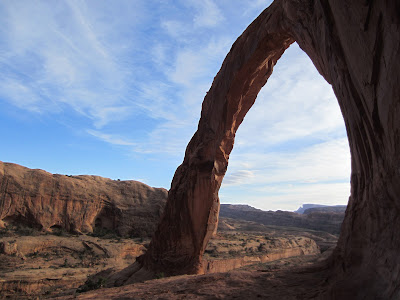
Arrived in Moab around 4:30pm, checked into the B&B, then headed out the Potash Road, 10.1 miles to the TH for Corona Arch. It was only a few miles round trip and we took our time scampering around on the slickrock and taking many pictures, really enjoying our freedom to wander and take our time without any responsibility.
Amazing excavation of sandstone for the RR tracks
Bowtie Arch
Corona Arch
Aliens?
Petroglyphs
Dinosaur Tracks
Walking above Hunter Canyon
Hunter Canyon
Which way? Where is that map?
Pritchett Arch
Extreme seems to be the name of the game in Moab. Here, the unicyclists have at it.
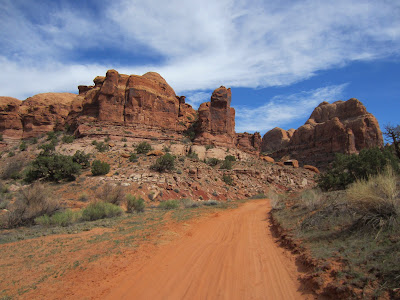
Our turnaround point was up the dirt road in the center, behind the large sandstone wall
In the afternoon, we headed over to Hunter Canyon for a 3.5 mile RT walk. Hunter Canyon is one of the few canyons with somewhat consistent water flow, tall trees and abundant vegetation.
Some rather large rocks have fallen, note Allison in the picture for scale
Cave of forgotten dreams.... This cave is MASSIVE and I tried to get up to it, but the going was a real scrubble scramble. I made it 3/4 of the way up, but opted to not push my luck, as there was too much loose rock and hangfire. I had to descend most of the upper part facing in and was a little sketched at times. With a helmet and someone like Homie, I might have made it though.
We decided to go to Moab, skip the camping and treat ourselves to a B&B, in order to make eating/relaxing as much a priority as the adventures we were also seeking. This last minute change was also precipitated by the fact that I got really sick on Tuesday (laryngitis I think) and even though I felt better by the time we left on Friday (still was not able to talk until Saturday), the thought of camping did not sound the least bit appealing.
Friday, 03/30/12 Corona Arch
We left home on Friday around 10:15am and took our time getting there and even stopped for a hike to Hanging Lakes, which we have discussed every time we have driven through Glenwood Canyon, but have never had the time to do. We followed the signs to Hanging Lake, exiting the highway at Exit 121/Grizzly Gulch, parked at the TH and Allison got a head start up the trail while I tied my shoes. A quick glance at the signboard announced that it was not the TH to Hanging Lakes.... WTF? Serious? I guess I did not do my homework (as I had always assumed that was the exit), so we just kept rolling West on I-70.
Arrived in Moab around 4:30pm, checked into the B&B, then headed out the Potash Road, 10.1 miles to the TH for Corona Arch. It was only a few miles round trip and we took our time scampering around on the slickrock and taking many pictures, really enjoying our freedom to wander and take our time without any responsibility.
Amazing excavation of sandstone for the RR tracks
Bowtie Arch
Corona Arch
Aliens?
Petroglyphs
Dinosaur Tracks
Saturday, 03/31/12 Hunter Canyon/Pritchett Canyon Loop
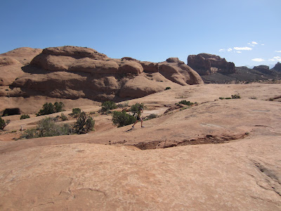
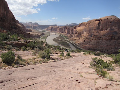
In no hurry, we spent a good part of the morning taking advantage of the second B of B&B and chatting with the owner who made us a fine meal. Finally around 9:30am, a few short miles of driving down Kane Creek Road from the B&B got us to the big lot where the road turns to dirt, where our plan was to walk/jog the few road miles to the mouth of Gatherer Canyon. A short stint through Gatherer and a little route finding brought us to the trail that traverses high above Hunter Canyon, where we enjoyed some nice rolling singletrack/doubletrack with expansive views.
Routefinding with a map and GPS made things quite easy. Could have done it without no problem I think, but it certainly added a nice level of comfort, as a small mistake could be very inconvenient at best. Took a side trip over to Pritchett Natural Bridge (or Arch depending on the map) and searched high and low for the shortcut indicated on the Latitude 40 map that I have (geared toward mountain biking). After a bit of poking around, we decided to give up and backtracked to where we originally left the Pritchett Canyon route.
It was an amazingly clear day and quite warm, 86 we would later find and it felt great to be out soaking it up. We had plenty of food and water and had it not been for developing toe blisters and another damaged toenail (thanks again to La Sportiva shoes, the Electron this time), I felt like I could have just been out there indefinitely. We took our sweet time descending Pritchett Canyon, as we discovered that we timed it just right with the Moab Easter Jeep Safari week and there were hordes of 4x4 enthusiasts testing their skills on the insanely technical road/trail (I am planning a separate post to cover that nuttiness).
We ended up getting in a touch over 15 miles for the loop with 2,000+ k of vert., in a little over 5 hours.
Starting up the dirt section of Kane Creek Road
Walking above Hunter Canyon
Hunter Canyon
Which way? Where is that map?
Pritchett Arch
Funny side story from a "non-drinker"
Those who know me, often get a kick out of my teetotaler ways. A few times per year, I will have a glass or of wine with dinner and once, maybe every 2-7 years, I will sip down a few margs, if the mood strikes me and if they happen to be free.
After cleaning up and relaxing at the B&B, we headed to the Moab Brewery for a well deserved dinner, where I was reminded of why I rarely, if ever drink.
While ordering, we noticed they had some fun flavored, 18oz. margaritas on the menu and noticed them on nearby tables. Feeling a bit carefree and celebratory of our hard earned and rare vacation time, I threw my general aversion to alcohol to the wind and ordered one up for Allison and I to split. We started sipping and before I knew it, it was gone, leaving behind a 13oz pile of ice. What? Seriously? $10.99 for a pile of ice? I stewed and stewed, now focused on how I felt ripped off. Stewed about how I would have been MUCH happier with a bottomless Coke or Lemonade for ~$2. Hah, good for a laugh I guess, I'll never spend another cent on alcohol.
Sunday, 04/01/12 Moab Rim Trail/Hunter Canyon
Headed up the Moab Rim Trail from the river in the morning, following a long line of Jeeps that had just started up. Climbing 900 feet in a bit under a mile, entirely on slickrock, this was my kind of trail and Allison gave me the nod to do my thing. I took off up the trail, with the intent of competing with the Jeeps, further inspired by the insistence of one of the workers at the B&B that suggested it would take us 45 minutes to get to the rim overlook. I was a little bogged from breakfast still, but my legs felt springy and I got into a good groove. Passing the Jeeps was WAY easier than I thought, but even so, turned on the gas a bit as I passed just to show them up (most of the drivers/passengers were the sedentary type and looked/commented in awe as I floated past). Also proved the B&B gal wrong in her 45 minute estimate, topping out in 13 minutes. Turned around to meet Allison, who was surprisingly just a minute or so down the trail (though she had a few minute head start).
From the rim, we hiked/jogged intermittently toward the overlook on the far side of the mesa, totaling 9 miles for the RT. Of course we took our time on the way back, spectating the Jeeping antics.
Great views of Moab
Our turnaround point was up the dirt road in the center, behind the large sandstone wall
In the afternoon, we headed over to Hunter Canyon for a 3.5 mile RT walk. Hunter Canyon is one of the few canyons with somewhat consistent water flow, tall trees and abundant vegetation.
Some rather large rocks have fallen, note Allison in the picture for scale
Cave of forgotten dreams.... This cave is MASSIVE and I tried to get up to it, but the going was a real scrubble scramble. I made it 3/4 of the way up, but opted to not push my luck, as there was too much loose rock and hangfire. I had to descend most of the upper part facing in and was a little sketched at times. With a helmet and someone like Homie, I might have made it though.
Monday, 04/02/12 Hanging Lake, Finally.
So, the trick for Hanging Lake (which I subconsciously knew all along and is part of the reason we have never been until now) is that if you are approaching from the East (there is no exit Westbound for Hanging Lake) you have to get off at the Grizzly Gulch exit (121), then backtrack on I-70 4 miles to the Hanging Lake exit. From the Hanging Lake exit (exit 125), you can not get back on I-70 Eastbound, so you have to backtrack West to exit 121 to turn around. No matter which way you are travelling, a trip to Hanging Lake requires 8 additional miles in the car. I have to say it is quite worth it though.
After a relaxing soak at Glenwood Hot Springs the previous night, we decided that we would figure out the Hanging Lake puzzle no matter what and finally check it out before we headed for home. The trail is very well maintained to the lake and though the lake is smaller than I anticipated (more like a pond), we were quite impressed. Seeing it in the off season was also quite a treat, as we shared the lake with two families for part of the time, yet otherwise had it to ourselves. Quite an amazing spot.
Subscribe to:
Posts (Atom)


