6.29 miles/1,083 vert./1:14 up/22 down
The "trail" (dirt road) is reasonably smooth for the most part and the gradient is pretty reasonable for running, even when pushing 100lbs of baby jogger in the snow, so I look to head back there again soon.
The girls were becoming a little impatient at the summit, so I was in a hurry to get them back down, not knowing what kind of speed would be reasonable going down the snowy trail. The first paved section was quick back down to Flagstaff Road and was fun chasing the jogger at 5:50 pace (though a bit scratchy wearing Ice Bug shoes), then we were moving at 6:?? pace for much of the Chapman descent, aside from a few rough spots where we had to slow waaay down. So pretty much a 5k descent in 22:39 which ended up being 7:19 pace.
All official (though I still felt as though I was getting away with something)
Glad to not be having to scuttle under this gate anymore
Isabelle having a blast
Amelie hiking along
Top(ish) of Flagstaff
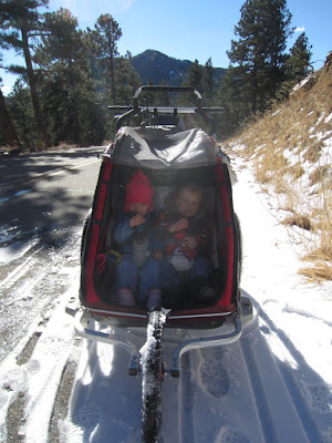
Thankful for the plastic canopy, as the often times free spinning front wheel really kicked up a severe rooster tail of snow.


The photo of the snow caked canopy from the rooster tail made me chuckle.
ReplyDeleteCool, I used to hit that trail and loop it around with Sandrock years ago. Good to know it is now legal. Now if they could get a legal connector from Anemonie Hill over to 4mile/Creek Path that would be cool. Still, the backside of Flag is always nice and quiet.
ReplyDeletePeter, yeah, that connecter would be great, as would connecting the upper section of creek path to Chapman. I now want to run this from town, but don't dare risk the ~3/10 mile running along the shoulder of Canyon with a double baby jogger. I wonder if this is being discussed? It only makes too much sense, but perhaps there are some private property/access issues to deal with. At ther very least, a wider/safer shoulder lane sort of thing would suffice.
ReplyDelete